I’m trying to make a simple flight controller for a model rocket, and after some frustration around accelerometers and fin-controlling servos (another post coming on that later) I figured out I could work on a different phase of the flight instead: detecting the apex of the trajectory. To do that I have decided to use a barometric pressure module with my TTGO LoRa32, more specificly the BMP180.
I haven’t got my yet, it is in transit from Germany. So while I wait I will write what I can and hopefully be more or less ready when I get to hook it up to the development board. Since I don’t have it, I will write the code to calculate height from the pressure readings, and a function that detects the apex based on the average of several readings.
The barometric pressure at a given height is very well known and understood, so it’s pretty easy to find a formula and a graph for it. The formula I’m using is

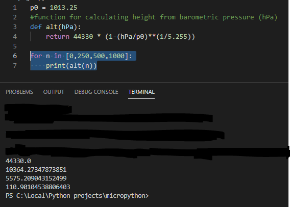
Assuming a P0 at 1013.25 hPa (I will calibrate by reading this at startup when I get the sensor, but this is good enough for now), the same function in python will be
p0 = 1013.25
#function for calculating height from barometric pressure (hPa)
def alt(hPa):
    return 44330 * (1-(hPa/p0)**(1/5.255))
which for a range of values gives us
which corresponds pretty good with this chart

Allright! We are now able to determine how high up we are, and can get started on detecting the apex. Roughly speaking, the trajectory is a smooth curve: as long as the altitude is increasing we haven’t reached the apex, and as long as the altitude is decreasing, the apex has been passed. That tells us that we need to compare readings to determine if the current altitude is greater than, equal to or less than the previous altitude. Ok, let’s create a function that tells us which part of the trajectory we’re currently at.
def getTrajectoryStage(lastAltitude, currentAltitude):
    if(lastAltitude < currentAltitude):
        return "ascending"
    if(lastAltitude == currentAltitude):
        return "apex"
    if(lastAltitude < currentAltitude):
        return "descending"
Easy peasy lemon sque… wait a minute. Real life called, we have to account for noise during reading and accuracy of the sensor as well! I’m thinking we should use an average of the last three readings. So we get three pressure readings, average them, get the altitude, store it, get three pressure readings, average them, get the altitude and compare it to the last, then keep comparing the altitude of the average of the three past pressure readings to the last until the vehicle is in a passive state (ie. on the ground) again. Since I don’t have a sensor yet, I’ll have to fake the data somehow.
I’m making the easy assumption that the trajectory is shaped like a smooth curve that is evenly distributed on the ascending and descending phase, while in reality there will probably be a quicker ascending rate while under rocket propulsion, then a decreasing ascending rate as the rocket is “free-falling upwards” until it reaches the apex and starts falling towards the ground again.
I figure a decent amount of measurements would be around 15 readings pr second (it’s capable of a lot more, but I’m being cautios for now since I don’t know how much processing power I’m going to need yet) and I’m guessing that the whole flight from launch to landing would take about 15 seconds? That means I have to create 125 measurements. I just divide the amount of required measurements by two and decrease the pressure until I get halfway, or reach apex, and then increase it again until I reach the end, or land. To determine how much to increase by I set a max pressure to reach at 900hPa, which is 988.6 meters, a decent height for a model rocket. I also decided to add noise by choosing a value by random in the range -0.12 to 0.12 hPa and add that to the current value. This helps me write code that probably will work better with the actual values from the sensor. The MBP180 has an accuracy of +-0.12hPa, so this should be good. Here’s how I implemented it in python:
import random

p0 = 1013.25
pMax = 900

#function for calculating height from barometric pressure (hPa)
def alt(hPa):
    return 44330 * (1-(hPa/p0)**(1/5.255))

#function for adding noise ()
def addNoise():
    noiseRange = range(-12,12,1)
    choice = random.choice(noiseRange)
    return choice/100 #create decimal range from -0.12 to 0.12

def createFlightPathPressure(nrOfReadings):
    readings = []
    lastReading = p0 # start at ground level

    middle = nrOfReadings // 2
    pressureDiff = p0 - pMax
    pressureIncrement = pressureDiff / middle

    for i in range(0,nrOfReadings,1):
        if i < middle:
            current = lastReading-pressureIncrement
            readings.append(current+addNoise()) #pressure gets lower on the way up
        if i >= middle:
            current = lastReading+pressureIncrement
            readings.append(current+addNoise()) #pressure gets higher on the way down
        lastReading = current

    return readings
Allright! This gives us the following output:
hpa: 1011.4733870967741, altitude (m): 14.80163586449273
hpa: 1009.6867741935483, altitude (m): 29.707829941324093
hpa: 1007.6501612903224, altitude (m): 46.72591277166945
hpa: 1005.8835483870967, altitude (m): 61.51042823206591
hpa: 1004.1569354838707, altitude (m): 75.98051965697563
hpa: 1002.3903225806449, altitude (m): 90.806702642288
hpa: 1000.513709677419, altitude (m): 106.57924592633084
hpa: 998.6670967741932, altitude (m): 122.1230455525329
hpa: 996.7104838709673, altitude (m): 138.6181800931914
hpa: 995.0238709677415, altitude (m): 152.85814710692006
hpa: 993.1172580645157, altitude (m): 168.9791140929862
hpa: 991.2406451612898, altitude (m): 184.870912523112
hpa: 989.504032258064, altitude (m): 199.59886071153787
hpa: 987.607419354838, altitude (m): 215.7076743100478
hpa: 985.9008064516122, altitude (m): 230.2241542686596
hpa: 983.9841935483864, altitude (m): 246.5511741704629
hpa: 982.1575806451606, altitude (m): 262.13549490466613
hpa: 980.4609677419347, altitude (m): 276.63171635024065
hpa: 978.5943548387088, altitude (m): 292.6039387157892
hpa: 976.787741935483, altitude (m): 308.0862626225589
hpa: 974.8011290322571, altitude (m): 325.1379412253283
hpa: 972.9945161290312, altitude (m): 340.66907389423255
hpa: 971.2279032258054, altitude (m): 355.87893017831937
hpa: 969.4612903225795, altitude (m): 371.11120423165517
hpa: 967.5246774193538, altitude (m): 387.8351151953878
hpa: 965.6880645161278, altitude (m): 403.72052142953993
hpa: 963.971451612902, altitude (m): 418.59014518789087
hpa: 961.9948387096762, altitude (m): 435.7385188779175
hpa: 960.3182258064503, altitude (m): 450.30657948481183
hpa: 958.5016129032244, altitude (m): 466.114361722635
hpa: 956.5049999999986, altitude (m): 483.5164739708832
hpa: 954.8583870967727, altitude (m): 497.8901948937508
hpa: 953.0017741935469, altitude (m): 514.1211542813832
hpa: 951.1251612903211, altitude (m): 530.5529980553663
hpa: 949.3685483870952, altitude (m): 545.95791187972
hpa: 947.5519354838693, altitude (m): 561.9133004818788
hpa: 945.6153225806436, altitude (m): 578.9499538504524
hpa: 943.7987096774177, altitude (m): 594.9566496253696
hpa: 941.9720967741919, altitude (m): 611.0766310296427
hpa: 940.295483870966, altitude (m): 625.8951458258184
hpa: 938.4288709677402, altitude (m): 642.4181395228651
hpa: 936.4422580645142, altitude (m): 660.0326147217847
hpa: 934.6856451612884, altitude (m): 675.6329984111127
hpa: 932.9790322580626, altitude (m): 690.8120870048217
hpa: 930.9324193548367, altitude (m): 709.0449051176527
hpa: 929.1258064516109, altitude (m): 725.1666069142855
hpa: 927.429193548385, altitude (m): 740.3298274532361
hpa: 925.5725806451592, altitude (m): 756.9487831579362
hpa: 923.7759677419333, altitude (m): 773.0563834198837
hpa: 921.9693548387074, altitude (m): 789.2792371915514
hpa: 920.1427419354816, altitude (m): 805.7078748885918
hpa: 918.2161290322558, altitude (m): 823.0645570874384
hpa: 916.53951612903, altitude (m): 838.1930247947685
hpa: 914.522903225804, altitude (m): 856.4191051029437
hpa: 912.8562903225783, altitude (m): 871.5064737801473
hpa: 910.9296774193524, altitude (m): 888.9753673303907
hpa: 909.0730645161266, altitude (m): 905.8378883723849
hpa: 907.3764516129007, altitude (m): 921.2716252820959
hpa: 905.4298387096749, altitude (m): 939.0083719485333
hpa: 903.743225806449, altitude (m): 954.4010873090325
hpa: 901.7266129032231, altitude (m): 972.8360786748403
hpa: 899.9899999999973, altitude (m): 988.7382036168628
hpa: 901.7566129032231, altitude (m): 972.5615873243753
hpa: 903.5732258064489, altitude (m): 955.9538665158714
hpa: 905.3898387096748, altitude (m): 939.373159333591
hpa: 907.3864516129007, altitude (m): 921.1805889185617
hpa: 909.0230645161265, altitude (m): 906.2923943632826
hpa: 910.8496774193524, altitude (m): 889.7013862153283
hpa: 912.7462903225783, altitude (m): 872.5030566272334
hpa: 914.6229032258041, altitude (m): 855.5145419718144
hpa: 916.4795161290299, altitude (m): 838.7348338988716
hpa: 918.1761290322557, altitude (m): 823.4252258308607
hpa: 920.0927419354816, altitude (m): 806.1579482926519
hpa: 921.8493548387074, altitude (m): 790.3577133276448
hpa: 923.6559677419333, altitude (m): 774.1331513316059
hpa: 925.4725806451592, altitude (m): 757.8446712600013
hpa: 927.459193548385, altitude (m): 740.0615120114993
hpa: 929.1058064516109, altitude (m): 725.3452232471748
hpa: 931.0624193548367, altitude (m): 707.8857992725563
hpa: 932.8390322580626, altitude (m): 692.0582833617226
hpa: 934.6456451612885, altitude (m): 675.9885125831543
hpa: 936.4322580645143, altitude (m): 660.1213570914294
hpa: 938.3088709677402, altitude (m): 643.4812726637853
hpa: 940.075483870966, altitude (m): 627.8411733618269
hpa: 942.0720967741918, altitude (m): 610.1934697198186
hpa: 943.9287096774177, altitude (m): 593.8103541003757
hpa: 945.6553225806435, altitude (m): 578.597782669627
hpa: 947.5919354838694, altitude (m): 561.5617122033942
hpa: 949.3685483870952, altitude (m): 545.95791187972
hpa: 951.1151612903211, altitude (m): 530.6406295229052
hpa: 952.9717741935469, altitude (m): 514.3836316643191
hpa: 954.6783870967728, altitude (m): 499.46267927415516
hpa: 956.7149999999987, altitude (m): 481.68476910252144
hpa: 958.3316129032245, altitude (m): 467.59490681885217
hpa: 960.2382258064504, altitude (m): 451.0022127271916
hpa: 961.9948387096762, altitude (m): 435.7385188779175
hpa: 963.9014516129021, altitude (m): 419.1969531862864
hpa: 965.7080645161279, altitude (m): 403.5474038423419
hpa: 967.6446774193537, altitude (m): 386.79804985961715
hpa: 969.3912903225796, altitude (m): 371.7152283058745
hpa: 971.2279032258054, altitude (m): 355.87893017831937
hpa: 973.0645161290313, altitude (m): 340.0668615762928
hpa: 974.7911290322571, altitude (m): 325.22384529201923
hpa: 976.707741935483, altitude (m): 308.7723831060423
hpa: 978.6243548387089, altitude (m): 292.34703991953785
hpa: 980.4209677419346, altitude (m): 276.9737298550467
hpa: 982.0875806451605, altitude (m): 262.73318861237044
hpa: 984.1241935483864, altitude (m): 245.3576870347122
hpa: 985.9208064516123, altitude (m): 230.05391612745444
hpa: 987.5874193548381, altitude (m): 215.8776770060802
hpa: 989.4040322580639, altitude (m): 200.447582509081
hpa: 991.3506451612898, altitude (m): 183.93872315924483
hpa: 993.0972580645157, altitude (m): 169.14835268042017
hpa: 994.9938709677415, altitude (m): 153.11161207934853
hpa: 996.8404838709673, altitude (m): 137.52140834287073
hpa: 998.5170967741932, altitude (m): 123.3866870126954
hpa: 1000.473709677419, altitude (m): 106.91569829443527
hpa: 1002.3203225806449, altitude (m): 91.39460869607855
hpa: 1004.1369354838707, altitude (m): 76.14825010529073
hpa: 1006.0435483870966, altitude (m): 60.170547025503346
hpa: 1007.6601612903224, altitude (m): 46.642284046016854
hpa: 1009.5567741935483, altitude (m): 30.79328836691562
hpa: 1011.3833870967742, altitude (m): 15.552020048086243
hpa: 1013.36, altitude (m): -0.9157606891750114
hpa: 1015.0166129032259, altitude (m): -14.697499613272793
Allright, neat! Smashing the numbers into a spreadsheet and hitting the graph button gives this graph:
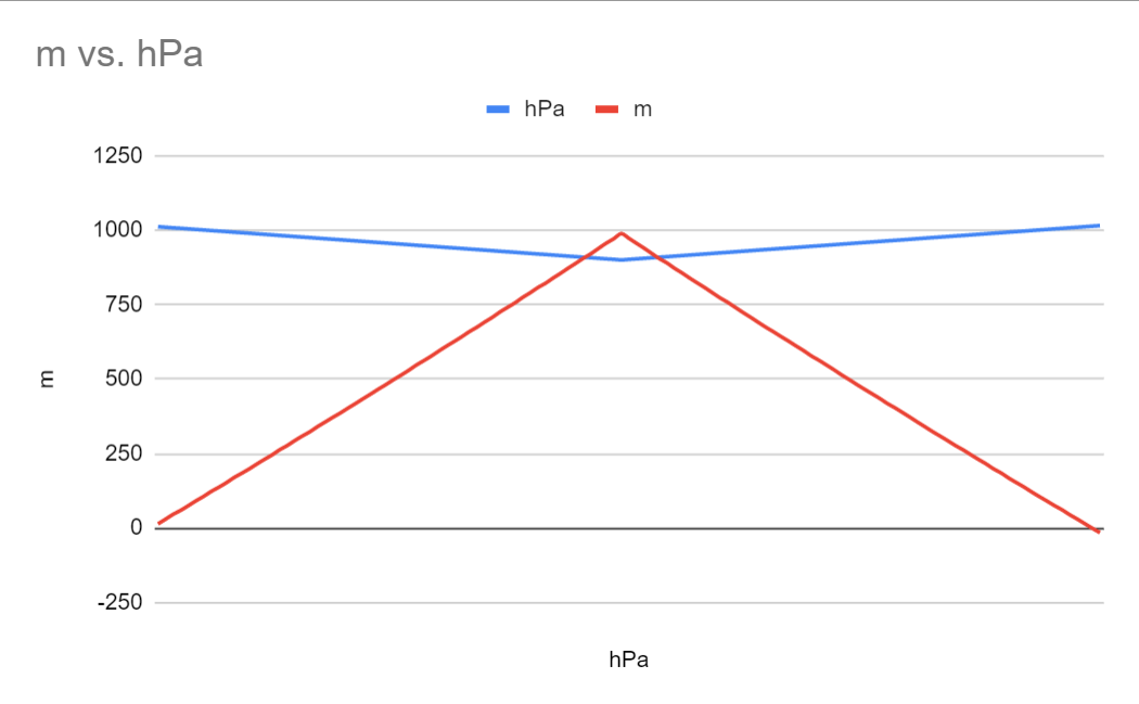
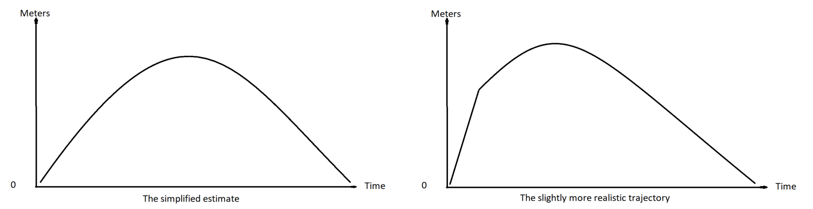
A bit more pointy than I expected, might smooth out the transition from ascending to descending later on. Also, the added noise doesn’t show.. Might be because the scale of the graph isn’t displaying precisely enough. I think I might try a different approach instead… Let’s think about this in terms of high school math! The trajectory is similar to a quadratic function, which we can represent in a vertex form where we already know two of the values: the highest point (on the Y-axis), and the number of steps, or readings, we want to create on the X-axis. Below is the quadratic function in vertex form:
f(x) = a(x-h)^2+kIn this formula, the h stands for where the graph is at its highest point (where the curve changes direction) along the x-axis, and k stands for the highest value along the y-axis. In our case, if we still assume 125 steps, x will be every value between 0 and 125. All that is left then is value a, which tells us how pointy the curve will be, and also in which direction it will be open. To solve for a we need to know two points, and we happen to know three! We want the curve to start at (0,0), we want the curve to have its apex to be at (62,900) which is half of the total steps (yes, I know 62 times 2 is 124…) and the total height we want to reach, and again our curve should reach the x axis (y=0) at (124,0). I changed the number of steps slightly to be able to divide with 2.

Ok, after more googling and trying than I want to admit, here’s my calculation of a for our graph:
vertex: (62,900)
point: (0,0) #we start at 0 readings at 0 altitude

y = a(x-h)^2+k
0 = a(0-62)^2+900
0 = a(-62)^2+900
0 = a * 3844 +900
-900 = a * 3844
-900/3844 = a
-0.2341311134235 ~ a

Our function: f(x) = -0.2341311134235(x-62)^2+900
Implementing this is python looks like this
def createTrajectory(maxHeight, nrOfSteps):
    a = -0.2341311134235
    h = nrOfSteps / 2
    k = maxHeight

    readings = []

    for x in range(0, nrOfSteps, 1):
        y = a * ((x - h)**2) + k
        readings.append((x,y))
    return readings

result = createTrajectory(900,124)
Now, you might be thinking this is not precise enough, but it’s close enought for the amount of testing I want to do until my sensor arrives (which should be soon!). The createTrajectory function with the specified input gives us a trajectory that is pretty steep, but I guess that’s how rockets fly anyways… I also came to think that x here is each reading from the sensor, and they will occur at a fixed timing with (hopefully) very little deviation. That means we can calculate the vertical speed of our rocket as well. If we assume that we are able to read the sensor every 100ms, taking calculations and stuff into consideration, we can calculate speed = distance over time like this in python:
def calculateVelocity(distance, ms):
    return abs((distance/ms) * 1000) # return speed in m/s as a positive value
I want the function to return it in meters pr second (distance is in meters) and I want the speed to be always positive which is why I use the abs() function. If I didn’t use that I would have gotten a negative velocity as the rocket descends. I guess that would have made it easier to calculate phase? Positive velocity equals ascending, and negative is descending. But instead I tried figuring out a way to calculate the angle of the current point in the trajectory relative to the ground. I know, math again! I had to do some googling again and came across a forum-post somewhere that had a solution I was able to translate into python, but unfortunately I can’t give any credit as I can’t recall where I found it! So whoever you are, dear forum hero person, thank you!
Here’s the formula for calculating the angle relative to the ground
def calculateFlightAngle(previousPoint, currentPoint):
        (x1, y1) = previousPoint
        (x2, y2) = currentPoint

        angle = math.atan2(y2 - y1, x2 - x1) * 180 / math.pi;
        return angle
If anyone would care to explain why this works, I would love to hear it. The parts I have figured out so far is that atan2 of the difference between point one and two gives us a vector in radians relative to a horizontal line (the ground), and that the following “* 180 / pi” translates that into degrees. Anyways, this works great, and now we have two inputs we can use to determine flight phase: vertical velocity and angle of the trajectory!
Again, just changing slighty the basic approach from earlier we can assume apex when angle is below a given threshold (on both negative and positive side), and vertical velocity at the same time is below a given threshold. Then, the ascending phase will be when the vertical velocity is above the velocity threshold and the angle is positive and above the angle threshold, while the descending phase is the same, but angle below negative velocity threshold. Here’s how I implemented it
def detectFlightPhase(angle, velocity):
        angleTolerance = 15     #degrees
        speedTolerance = 3      #meters pr second
        if angle > angleTolerance and velocity > speedTolerance:
            return "ascending"
        if angle < angleTolerance * -1 and velocity > speedTolerance: # negative angle when descending
            return "descending"
        if angle < angleTolerance and angle > angleTolerance * -1 and velocity < speedTolerance:
            return "apex"
The tolerance values are selected based on what values I got in the middle of the trajectory so that at least a few values for x would be within the apex. I think they are way to high for a real rocket, but for a proof of concept I guess they’re fine. I actually had to fiddle around a bit to get the trajectory code to work, and since I can’t be on my computer all the time I started using Pydroid3 which works great for stuff like this! Have a look at this short post I wrote about it: Python on Android with pydroid 3
Putting it all together with pretty printing and everything the complete code looks like this
import math
import random
import queue

p0 = 1013.25
pMax = 900

#function for calculating height from barometric pressure (hPa)
def alt(hPa):
    return 44330 * (1-(hPa/p0)**(1/5.255))

def addNoise():
    noiseRange = range(-12,12,1)
    choice = random.choice(noiseRange)
    return choice/100 #create decimal range from -0.12 to 0.12

def getTrajectoryStage(altList):
    last = altList[0]
    for n in altList:
        if lastAltitude < currentAltitude:
            return "ascending"
        if lastAltitude == currentAltitude:
            return "apex"
        if lastAltitude > currentAltitude:
            return "descending"

def createTrajectory(maxHeight, nrOfSteps):
    a = -0.2341
    h = nrOfSteps / 2
    k = maxHeight

    readings = []

    for x in range(0, nrOfSteps, 1):
        y = a * ((x - h)**2) + k
        readings.append((x,y))
    return readings

def calculateFlightAngle(previousPoint, currentPoint):
        (x1, y1) = previousPoint
        (x2, y2) = currentPoint

        angle = math.atan2(y2 - y1, x2 - x1) * 180 / math.pi;
        return angle

def calculateVelocity(distance, ms):
    return abs((distance/ms) * 1000) # return speed in m/s as a positive value

def detectFlightPhase(angle, velocity):
        angleTolerance = 15     #degrees
        speedTolerance = 3      #meters pr second
        if angle > angleTolerance and velocity > speedTolerance:
            return "ascending"
        if angle < angleTolerance * -1 and velocity > speedTolerance: # negative angle when descending
            return "descending"
        if angle < angleTolerance and angle > angleTolerance * -1 and velocity < speedTolerance:
            return "apex"

result = createTrajectory(900,126)
previousX = 0
previousY = 0
timeBetweenReadings = 100
dash = '-' * 76

for value in result:
    (reading,altitude) = value
    if reading == 0: #print headers
        print(dash)
        print('{:<4s} {:<19s} {:<19s} {:<20s} {:<11}'.format("X","ALTITUDE (M)","ANGLE (DEG)","VELOCITY (M/S)","PHASE"))
        print(dash)
    else: #print values
        angle = calculateFlightAngle((previousX, previousY), (reading, altitude))
        velocity = calculateVelocity(altitude - previousY, timeBetweenReadings)
        phase = detectFlightPhase(angle, velocity)
        print('{:<4s} {:<19s} {:<19s} {:<20s} {:<11}'.format(str(reading),str(altitude),str(angle),str(velocity), str(phase)))
        previousX = reading
        previousY = altitude
And running the code gives a printout like this
----------------------------------------------------------------------------
X    ALTITUDE (M)        ANGLE (DEG)         VELOCITY (M/S)       PHASE
----------------------------------------------------------------------------
1    0.11959999999999127 6.820179371688774   1.1959999999999127   apex
2    28.913900000000012  88.01096879720959   287.9430000000002    ascending
3    57.24000000000001   87.97811931364735   283.26099999999997   ascending
4    85.09789999999998   87.94416704353242   278.5789999999997    ascending
5    112.48760000000004  87.90905553161382   273.8970000000006    ascending
6    139.40909999999997  87.87272440404094   269.21499999999924   ascending
7    165.86239999999998  87.83510902253394   264.53300000000013   ascending
8    191.84749999999997  87.7961401012896    259.8509999999999    ascending
9    217.36440000000005  87.75574328185536   255.16900000000075   ascending
10   242.4131            87.71383866049345   250.4869999999994    ascending
11   266.9936            87.67034026172705   245.8050000000003    ascending
12   291.1059            87.62515545078479   241.12300000000005   ascending
13   314.75              87.57818427651213   236.4409999999998    ascending
14   337.92589999999996  87.52931873496183   231.75899999999956   ascending
15   360.6336            87.4784419422711    227.07700000000045   ascending
16   382.8731            87.42542720352387   222.3950000000002    ascending
17   404.6444            87.37013696202273   217.71299999999997   ascending
18   425.9475            87.31242161067198   213.03099999999972   ascending
19   446.7824            87.25211814390603   208.34900000000005   ascending
20   467.1491            87.18904862465587   203.6669999999998    ascending
21   487.0476            87.12301843608061   198.98500000000013   ascending
22   506.4779            87.05381428199543   194.30299999999988   ascending
23   525.44              86.98120189285875   189.62100000000078   ascending
24   543.9339            86.90492338551408   184.9389999999994    ascending
25   561.9596            86.82469421420804   180.2570000000003    ascending
26   579.5171            86.74019963719451   175.57500000000005   ascending
27   596.6064            86.65109060680172   170.8929999999998    ascending
28   613.2275            86.55697897028016   166.21099999999956   ascending
29   629.3804            86.45743184289329   161.52900000000045   ascending
30   645.0651            86.35196498199089   156.8470000000002    ascending
31   660.2816            86.24003494913934   152.16499999999996   ascending
32   675.0299            86.12102979397275   147.48299999999972   ascending
33   689.31              85.99425792448716   142.80099999999948   ascending
34   703.1219            85.85893473884637   138.11900000000037   ascending
35   716.4656            85.71416647626805   133.43700000000013   ascending
36   729.3411            85.55893058927718   128.75499999999988   ascending
37   741.7484            85.39205173258632   124.07299999999964   ascending
38   753.6875            85.2121721852426    119.39100000000053   ascending
39   765.1584            85.01771514393768   114.70900000000029   ascending
40   776.1611            84.80683880499954   110.02700000000004   ascending
41   786.6956            84.57737842936282   105.3449999999998    ascending
42   796.7619            84.32677256726195   100.66299999999956   ascending
43   806.36              84.05196816865899   95.98100000000045    ascending
44   815.4899            83.7492972073994    91.2990000000002     ascending
45   824.1516            83.41431436584993   86.61699999999996    ascending
46   832.3451            83.04158072526104   81.93499999999972    ascending
47   840.0704            82.62437140923232   77.25299999999947    ascending
48   847.3275            82.15427427257053   72.57100000000037    ascending
49   854.1164            81.62062952076032   67.88900000000012    ascending
50   860.4371            81.00973221393565   63.20699999999987    ascending
51   866.2896            80.30367307124884   58.524999999999636   ascending
52   871.6739            79.47861319293902   53.84300000000053    ascending
53   876.59              78.50214709190075   49.161000000000286   ascending
54   881.0379            77.32914966064662   44.47900000000004    ascending
55   885.0176            75.89501029912745   39.7969999999998     ascending
56   888.5291            74.10418189482591   35.114999999999554   ascending
57   891.5724            71.80995903830294   30.433000000000447   ascending
58   894.1475            68.77709433803787   25.751000000000204   ascending
59   896.2544            64.60953564496329   21.06899999999996    ascending
60   897.8931            58.60679549537291   16.386999999999716   ascending
61   899.0636            49.49155079659315   11.704999999999472   ascending
62   899.7659            35.08036781518804   7.023000000000366    ascending
63   900.0               13.175673913342347  2.341000000000122    apex
64   899.7659            -13.175673913342347 2.341000000000122    apex
65   899.0636            -35.08036781518804  7.023000000000366    descending
66   897.8931            -49.49155079659315  11.704999999999472   descending
67   896.2544            -58.60679549537291  16.386999999999716   descending
68   894.1475            -64.60953564496329  21.06899999999996    descending
69   891.5724            -68.77709433803787  25.751000000000204   descending
70   888.5291            -71.80995903830294  30.433000000000447   descending
71   885.0176            -74.10418189482591  35.114999999999554   descending
72   881.0379            -75.89501029912745  39.7969999999998     descending
73   876.59              -77.32914966064662  44.47900000000004    descending
74   871.6739            -78.50214709190075  49.161000000000286   descending
75   866.2896            -79.47861319293902  53.84300000000053    descending
76   860.4371            -80.30367307124884  58.524999999999636   descending
77   854.1164            -81.00973221393565  63.20699999999987    descending
78   847.3275            -81.62062952076032  67.88900000000012    descending
79   840.0704            -82.15427427257053  72.57100000000037    descending
80   832.3451            -82.62437140923232  77.25299999999947    descending
81   824.1516            -83.04158072526104  81.93499999999972    descending
82   815.4899            -83.41431436584993  86.61699999999996    descending
83   806.36              -83.7492972073994   91.2990000000002     descending
84   796.7619            -84.05196816865899  95.98100000000045    descending
85   786.6956            -84.32677256726195  100.66299999999956   descending
86   776.1611            -84.57737842936282  105.3449999999998    descending
87   765.1584            -84.80683880499954  110.02700000000004   descending
88   753.6875            -85.01771514393768  114.70900000000029   descending
89   741.7484            -85.2121721852426   119.39100000000053   descending
90   729.3411            -85.39205173258632  124.07299999999964   descending
91   716.4656            -85.55893058927718  128.75499999999988   descending
92   703.1219            -85.71416647626805  133.43700000000013   descending
93   689.31              -85.85893473884637  138.11900000000037   descending
94   675.0299            -85.99425792448716  142.80099999999948   descending
95   660.2816            -86.12102979397275  147.48299999999972   descending
96   645.0651            -86.24003494913934  152.16499999999996   descending
97   629.3804            -86.35196498199089  156.8470000000002    descending
98   613.2275            -86.45743184289329  161.52900000000045   descending
99   596.6064            -86.55697897028016  166.21099999999956   descending
100  579.5171            -86.65109060680172  170.8929999999998    descending
101  561.9596            -86.74019963719451  175.57500000000005   descending
102  543.9339            -86.82469421420804  180.2570000000003    descending
103  525.44              -86.90492338551408  184.9389999999994    descending
104  506.4779            -86.98120189285875  189.62100000000078   descending
105  487.0476            -87.05381428199543  194.30299999999988   descending
106  467.1491            -87.12301843608061  198.98500000000013   descending
107  446.7824            -87.18904862465587  203.6669999999998    descending
108  425.9475            -87.25211814390603  208.34900000000005   descending
109  404.6444            -87.31242161067198  213.03099999999972   descending
110  382.8731            -87.37013696202273  217.71299999999997   descending
111  360.6336            -87.42542720352387  222.3950000000002    descending
112  337.92589999999996  -87.4784419422711   227.07700000000045   descending
113  314.75              -87.52931873496183  231.75899999999956   descending
114  291.1059            -87.57818427651213  236.4409999999998    descending
115  266.9936            -87.62515545078479  241.12300000000005   descending
116  242.4131            -87.67034026172705  245.8050000000003    descending
117  217.36440000000005  -87.71383866049345  250.4869999999994    descending
118  191.84749999999997  -87.75574328185536  255.16900000000075   descending
119  165.86239999999998  -87.7961401012896   259.8509999999999    descending
120  139.40909999999997  -87.83510902253394  264.53300000000013   descending
121  112.48760000000004  -87.87272440404094  269.21499999999924   descending
122  85.09789999999998   -87.90905553161382  273.8970000000006    descending
123  57.24000000000001   -87.94416704353242  278.5789999999997    descending
124  28.913900000000012  -87.97811931364735  283.26099999999997   descending
125  0.11959999999999127 -88.01096879720959  287.9430000000002    descending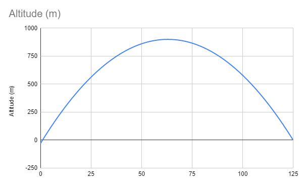
You might have realised I skipped using the noise-generator and the function for calculating altitude from barometric pressure, but since I ended up creating a trajectory in meters I didn’t need it. I will however need it once the BMP180 gets here!
I’m pretty pleased with how this turned out in the end! It’s my first time trying to make anything related to stuff that goes in the air so I might be surprised when I try to run this on an actual device, but I know that I have used some assumptions and estimates here that are likely to be a bit off, and won’t use this on a real rocket on the first go. As soon as I get my sensor I will start implementing this on an ESP32 and write a similar post explaining what I got right and what I got wrong in this post, so stay tuned!